Argentina – The End of Ruta 40 & Reaching Ushuaia – Patagonia & Tierra del Fuego / Fin del Mundo
- 10. Nov. 2025
- 14 Min. Lesezeit
Aktualisiert: 11. Nov. 2025

Ja wir haben es geschafft! Die komplette "Ruta 40", einmal vom Norden nach Süden!! Zur Info, die Kilometeranzeige nach "La Quiaca" (unserem Startort) auf dem Foto/Schild stimmt nicht. Es sollen nach Wikipedia rund 5,301km sein... ;)
Aber bleiben wir besser in der richtigen zeitlichen Reihenfolge der Strecke...
Nachdem wir die ersten Sektionen der „Ruta 40“ im Norden bewältigt hatten, ging es nun in großen Schritten auf Asphalt zum nächsten größeren Ziel der Stadt „Mendoza“.
Mendoza ist bekannt für sein Weinanbaugebiet und besonders für die Rebsorte/Wein, den „Malbec“. Daher haben wir uns 3 Nächste in Mendoza gegönnt und haben an einem Nachmittag eine 6-stündige geführte Tour in die Anbaugebiete gemacht. Es wurden 3 Winzer „Bodegas“ und ein Olivenölhersteller besucht. Überall durfte ein wenig gekostet werden ;) Eine Flasche haben wir uns auch, für einen kommenden Campingabend, mitgenommen…
Mendoza als Stadt hat uns auch sehr gut gefallen. Diese liegt eigentlich in einem Wüstengebiet an den Füßen der Anden, aber durch die vielen Bäume an den Straßen wirkte Sie „grün“ und es gab immer Schatten. Durch die vielen Kioske, Bars und Restaurants wirkt Mendoza auch ganz lebendig. Hier könnte man gerne in Zukunft nochmals vorbeikommen und zusätzliche 1-2 Tage bleiben…
In Mendoza hatte ich (Thilo) mir auch für mein Motorrad eine Lenkraderhöhung besorgt, um beim off-road-fahren im Stehen ein wenig gerader stehen zu können. Leider passte das gekaufte Stück dann doch nicht. Na ja, als Alternative haben wir daher die Position des Lenkers ein wenig angepasst und dabei die Griffe etwas nach oben „gedreht“. Mal schauen, ob dies etwas in den kommenden off-road Passagen hilft.
Yes, we did it! We completed the entire Ruta 40, from north to south! For your information, the mileage indicator to La Quiaca (our starting point) on the photo/sign is incorrect. According to Wikipedia, it should be around 5,301 km... ;)
But let's stick to the correct chronological order of the route...
After completing the first sections of the “Ruta 40” in the north, we made great strides on asphalt towards our next major destination, the city of “Mendoza.”
Mendoza is known for its wine-growing region and especially for the grape variety/wine called “Malbec.” So we treated ourselves to three nights in Mendoza and spent one afternoon on a six-hour guided tour of the wine-growing regions. We visited three wineries (“bodegas”) and an olive oil producer. We were allowed to taste a little bit of everything ;) We also bought a bottle to take with us for an upcoming camping evening...
We also really liked the city of Mendoza. It is actually located in a desert area at the foot of the Andes, but the many trees lining the streets made it seem “green” and there was always shade. The many kiosks, bars, and restaurants also make Mendoza seem very lively. We would love to come back here in the future and stay for an extra day or two...
In Mendoza, I (Thilo) also bought a handlebar riser for my motorcycle so that I could stand a little straighter when riding off-road. Unfortunately, the one I bought didn't fit. As an alternative, we adjusted the position of the handlebars a little and “turned” the grips slightly upwards. Let's see if this helps in the upcoming off-road passages.


Als nächstes Fahrziel, von Mendoza aus entlang der „Ruta 40“, war eine Hotelruine rund 60km abseits unserer eigentlichen Strecke gelegen. Und dies natürlich mal wieder off-road… In San Pedro de Atacama, Chile, hatte uns ein anderer Langzeitreisender aus Belgien den Tipp gegeben, dort vorbeizuschauen… also sind wir los… Die Strecke war für Marc wieder „ok“, obwohl er sein Motorrad an einem Streckenabschnitt abgelegt hatte. O-Ton Marc: “Hätte ich längere Beine, wäre das nicht passiert“. Ich (Thilo) kann es nicht beurteilen, da ich wie üblich auf off-road Strecken, um einiges langsamer unterwegs bin und daher die Situation nicht gesehen habe… ;) Beim Aufrichten des Motorrades habe ich (Thilo) mich jedenfalls gut verhoben und plage mich seitdem ein wenig mit einem leichten Hexenschuss herum… na ja, mal sehen, wann und wie der wieder verschwindet. Fürs erste hat eine Schmerztablette (Ibo) am Morgen geholfen ;)
Diese Hotelruine jedenfalls hat auch eine interessante Geschichte. Das Hotel „Termas el Sosneado“ ist ein ehemaliges Thermalhotel in der argentinischen Provinz Mendoza, dass in den 1930er Jahren erbaut wurde. Die Geschichte des Hotels ist eng mit dem Absturz des uruguayischen Fluges 571 verbunden, der 1972 in den Anden abstürzte und bei dem das Hotel als Orientierungspunkt für die Suchteams diente. Heute ist die Hotelruine, eine Art Touristenattraktion. Die Hotelruine wird auch in Verbindung mit Juan Domingo Perón gebracht (ehemaliger mehrmaliger Präsident Argentiniens), der damals in Mendoza stationiert war und sich angeblich mit deutschen „Nazis“ in diesem Hotel getroffen haben soll. Ob dies wirklich alles so stimmt, konnten wir nicht endgültig im Netz herausfinden… es macht diesen Ort jedenfalls interessant.
Die Landschaft bzw. das Tal war jedenfalls sehr schön. Die Nacht im Zelt bzw. im „Hotel“ bei unter 0°C, Wind und Schneeregen doch schon eher auf der frischen Seite. Aber alle sechs anwesenden „Touristen“ waren mit dem Abstecher dorthin am nächsten Morgen gut zufrieden.
Our next destination, starting from Mendoza along Ruta 40, was a ruined hotel located about 60 km off our actual route. And, of course, this meant going off-road again... In San Pedro de Atacama, Chile, another long-term traveler from Belgium had recommended that we stop by there... so off we went... The route was “ok” for Marc again, even though he had to put his motorcycle down on one section of the route. Marc said: “If I had longer legs, that wouldn't have happened.” I (Thilo) can't judge, as I'm usually a lot slower on off-road routes and therefore didn't see the situation... ;) In any case, I (Thilo) overexerted myself when picking up the motorcycle and have been struggling with a slight backache ever since... well, let's see when and how it goes away. For now, a painkiller (Ibo) in the morning has helped ;)
This hotel ruin also has an interesting history. The Hotel Termas el Sosneado is a former spa hotel in the Argentine province of Mendoza that was built in the 1930s. The history of the hotel is closely linked to the crash of Uruguayan Flight 571, which crashed in the Andes in 1972 and for which the hotel served as a landmark for the search teams. Today, the hotel ruins are a kind of tourist attraction. The hotel ruins are also associated with Juan Domingo Perón (former multiple president of Argentina), who was stationed in Mendoza at the time and is said to have met with German “Nazis” in this hotel. We couldn't find out for sure online whether this is really true... but it certainly makes this place interesting.
The landscape and the valley were very beautiful. The night in the tent or “hotel” was rather chilly, with temperatures below 0°C, wind, and sleet. But all the six “tourists” present were very satisfied with the detour there the next morning.


Nach einer Nacht in der Hotelruine ging es erst wieder die 60km off-road zurück zur „Ruta 40“ und dann immer weiter, auf dieser zu diesem Zeitpunkt asphaltierten Straße, Richtung Süden. Einen Zwischenstopp zum Übernachten haben wir in „Bardas Blancas“ gemacht, bevor es dann auf dem Weg zum nächsten Übernachtungsziel „Chos Malal“ nochmals über ca. 82km auf mal fester und mal lockerer Schotterstraße weiterging. Wie schon zuvor beschrieben, fährt Marc auf diesen off-road Passagen immer ein paar Kurven voraus, um mich dann nach einer gewissen Wartezeit wieder in Empfang zu nehmen… ;)
After spending the night in the hotel ruins, we first drove 60 km off-road back to Ruta 40 and then continued south on this paved road. We made a stopover in Bardas Blancas before continuing on to our next destination, Chos Malal, covering another 82 km on gravel roads that were sometimes firm and sometimes loose. As described earlier, Marc always rides a few turns ahead on these off-road passages and then waits for me after a certain amount of time... ;)


Auf dem Weg zum nächsten größeren und bekannteren Ort „San Carlos de Bariloche“ ging es über über ein 82km langes off-road Stück und die wirklich schöne und aspahltierte Strecke „Ruta de los Siete Lagos“ an sieben Seen vorbei. Die Landschaft wurde auch „grüner“ und bewaldeter und hat uns an die Alpen/Schwarzwald erinnert. War jedenfalls eine gute Abwechslung von den eher kargen/hügeligen Abschnitten der letzten Tage.
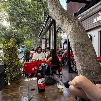
In Bariloche haben wir einen vollen Tag verbracht. Wir sind mit einer Seilbahn hoch zum „Cerro Otto“, um einen wirklich schönen Überblick auf eine Bergkette, den See und die Landschaft, um Bariloche herum, zu bekommen. Auch 1-2 lokale „Mikro-Brauereien“ haben wir am ersten Abend getestet. Wir müssen aber sagen, dass keine wirklich gutes „normales“ Bier/Pilsener nach unserem Geschmack gebraut hat. Die meisten sind „IPAs“ und andere mit Geschmack versehende Biere… nicht wirklich unser „Gusto“ ;). Aber probieren mussten wir ja…
On the way to the next larger and better-known town, San Carlos de Bariloche, we had another 82km long off-road stretch and took the truly beautiful and paved Ruta de los Siete Lagos route, passing seven lakes. The landscape also became greener and more wooded, reminding us of the Alps/Black Forest. In any case, it was a nice change from the rather barren/hilly sections of the last few days.
We spent a full day in Bariloche. We took a cable car up to Cerro Otto to get a really beautiful view of the mountain range, the lake, and the landscape around Bariloche. We also tried out one or two local microbreweries on our first evening. However, we have to say that none of them brewed a really good “normal” beer/pilsner to our taste. Most of them are IPAs and other flavored beers... not really our cup of tea ;). But, of course, we had to try them...


Nach dem Ruhetag in Bariloche ging es wieder weiter auf der Ruta 40 Richtung Süden. Mit 1-2 Übernachtungen auf dem Weg ging es zur nächsten bekannteren touristischen Stadt nach „El Calafate“. Der letzte Abschnitt führte uns über rund 400km nach El Calafate. Der Wind war schon grenzwertig. Bei der Ankunft im Hotel haben wir mitbekommen, dass es eine Wetterwarnung/Windwarnung gab und von Windgeschwindigkeiten von bis zu 90km/h zu rechnen ist. Dies hatte für uns in der Praxis auf der Straße die Bedeutung, dass wir zwischenzeitlich eine ordentliche Schräglage hatten und bei Böen gerne 1-2 Meter zur Seite geschoben wurden…Wir waren jedenfalls sehr froh, dann in El Calafate angekommen zu sein. Generell steuern wir, sofern möglich, immer den nationalen Tankstellenbetreiber „YPF“ nach einem Streckenabschnitt an. Zum einen um zu tanken, aber wichtiger sind noch die zugehörigen „Kaffees/Restaurant“, die seit dem Norden sehr oft an den Tankstellen anzutreffen sind. Dort wird dann immer neue Energie geschöpft für die Weiterfahrt bzw. eine Unterkunft in dem Ort/Stadt ausgesucht.
After a day of rest in Bariloche, we continued south on Ruta 40. With one or two overnight stays along the way, we headed to the next well-known tourist town, El Calafate. The last section of our journey, covering around 400 km to El Calafate, was already borderline windy. Upon arrival at the hotel, we learned that there was a weather warning/wind warning and that wind speeds of up to 90 km/h were to be expected. In practice, this meant that we were leaning at quite an angle on the road and were often pushed 1-2 meters to the side by gusts of wind... In any case, we were very happy to arrive in El Calafate. In general, whenever possible, we always head for the national gas station operator “YPF” after a stretch of road. On the one hand, to refuel, but more importantly, to visit the associated “cafés/restaurants,” which have been very common at gas stations since the north. There, we always recharge our batteries for the rest of the journey or look for accommodation in the town/city.
Zusätzlich war auf dem Weg noch eine in Argentinien bekannter Abschnitt der Ruta 40, dieser wird auch auf spanisch „Los 73 Merdidos“ genannt. Die „73 verfluchten/verdammten Kilometer“. Diese haben ihren ominösen Spitznamen aufgrund des schlechten Zustands der Straße, die in Teilen aus instabilem Schotter besteht und zudem den für diese Gegend typischen starken Winden ausgesetzt ist. Und dieser Zustand gibt es aus einem Grund: Korruption. Die Strecke ist bereits modern und breit angelegt, und alle Erdarbeiten wie das Abtragen von Hügeln, Brücken und Aufschüttungen scheinen abgeschlossen zu sein. Teilweise sieht es so aus, als ob nur noch der Asphalt aufgebracht werden muss. Es gibt Gerichtsverfahren, um die Verantwortung zu klären, und es gibt genügend Informationen in der Presse, um die korrupte Dynamik zu erklären, die dazu geführt hat, dass dieser Streckenabschnitt nicht asphaltiert wurde. Aber bis jetzt scheint nichts weiter an Arbeiten geplant zu sein. Wir haben zumindestens nichts an Vorbereitungen/Bauarbeiten ausmachen können.
In addition, there was a section of Ruta 40, well known in Argentina, which it is also called “Los 73 Merdidos” in Spanish. The “73 cursed kilometers.” These have their ominous nickname due to the poor condition of the road, which consists in parts of unstable gravel and is also exposed to the strong winds typical of this area. And there is a reason for this condition: corruption. The route is already modern and wide, and all the earthworks, such as the removal of hills, bridges, and embankments, appear to be complete. In some places, it looks as if all that remains is to lay the asphalt. There are court proceedings to clarify responsibility, and there is enough information in the press to explain the corrupt dynamics that led to this section of the road not being paved. But so far, no further work seems to be planned. At least, we haven't seen any preparations or construction work.


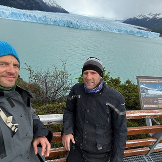
Von hier in „El Calafate“ aus sind es jedenfalls nur noch ca. 70km bis zum beeindruckenden Gletscher „Perito Moreno“. (Zur Info: Der Gletscher hieß früher Bismarck-Gletscher. Im Jahr 1899 hatte ihn sein Entdecker, der deutsche Geologe Rudolph Hauthal, nach dem im Vorjahr verstorbenen ehemaligen Reichskanzler Otto von Bismarck benannt. Er wurde erst später nach Perito Moreno benannt, als Würdigung dessen Verdienstes als Entdecker und Anthropologe. In Deutschland war der Name Bismarck-Gletscher bis mindestens 1917 üblich.) Hier nun ein paar Eindrücke vom Gletscher.
From here in El Calafate, it is only about 70 km to the impressive Perito Moreno Glacier. (Fun fact: The glacier was formerly known as the Bismarck Glacier. In 1899, its discoverer, the German geologist Rudolph Hauthal, named it after the former Reich Chancellor Otto von Bismarck, who had died the previous year. It was only later renamed Perito Moreno in recognition of his achievements as an explorer and anthropologist. In Germany, the name Bismarck Glacier was commonly used until at least 1917.) Here are now a few impressions of the glacier.


Generell ist es auch sehr interessant zu sehen, wie das Thema der „Falklandinseln“ noch immer im öffentlichen Raum in Argentinien hochgehalten wird. Die Falklandinseln heißen auf spanisch „Islas Malvinas“ und seit wir den Norden Argentiniens verlassen haben, wird auf Straßenschildern immer wieder mal darauf hingewiesen, dass die zu Argentinien gehören. (Hintergrundinformation aus Wikipedia: Das Vereinigte Königreich behauptete seine Ansprüche, indem es 1833 einen Flottenstützpunkt auf der Insel errichtete und die argentinische Verwaltung zum Abzug zwang. Die Inseln werden seitdem von Argentinien beansprucht und 1982 führte diese Auseinandersetzung zum Falklandkrieg. Die militärische Besetzung der Inseln durch Argentinien am 2. April 1982 löste diesen Krieg aus und Großbritannien reagierte und landete sieben Wochen später mit Truppen auf den Inseln. Nach kurzen, aber blutigen Kämpfen konnten die britischen Truppen Argentinien am 14. Juni 1982 zur Aufgabe bewegen.)
In general, it is also very interesting to see how the issue of the Falkland Islands is still held in high regard in the public sphere in Argentina. The Falkland Islands are called “Islas Malvinas” in Spanish, and since we left northern Argentina, road signs have repeatedly pointed out that they belong to Argentina. (Background information from Wikipedia: The United Kingdom asserted its claims by establishing a naval base on the island in 1833 and forcing the Argentine administration to withdraw. Argentina has claimed the islands ever since, and in 1982 this dispute led to the Falklands War. Argentina's military occupation of the islands on April 2, 1982, triggered this war, and Great Britain responded by landing troops on the islands seven weeks later. After brief but bloody fighting, British troops were able to persuade Argentina to surrender on June 14, 1982.)

Bevor es auf die letzten rund 730km auf der Ruta 40 zum End bzw. Startpunkt dieser Nationalstraße geht, haben wir in „El Calafate“ am 2ten Tag noch den ersten Ölwechsel für die Motorräder organisiert und die Ketten wieder spannen, säubern und schmieren lassen. Zudem wurde sich um die Wäsche gekümmert.
Before tackling the last 730 km or so on Ruta 40 to the end or starting point of this national road, we organized the first oil change for the motorcycles in El Calafate on the second day and had the chains tightened, cleaned and lubricated again. We also took care of the laundry.


Dies alles erledigt, ging es zügig wieder zurück auf die "Ruta 40". Mit gemäßigten Windbedingungen von Böen bis "nur" 50-60 km/h und zwei Übernachtungen in den Städten "28 de Noviembre" und "Rio Gallegos" (mit nochmals ca. 100km guter off-road Strecke) ging es weiter zum Start bzw. Endpunkt der Ruta 40.
With all that done, we quickly headed back to Ruta 40. With moderate wind conditions of gusts of “only” 50-60 km/h and two overnight stays in the towns of “28 de Noviembre” and “Rio Gallegos” (with another 100 km of good off-road track), we continued to the start and end point of Ruta 40.


Mit dem erreichen dieses Punktes waren wir (wie am Anfang des Blogeintrages schon erwähnt) über ca. 5,301km von Nord- nach Südargentien auf einer einzigen Nationalstraße unterwegs. Wie hoffentlich in den beiden Blogbeiträgen über die "Ruta 40" ersichtlich sind wir durch unterschiedlichste Landschaften, Straßen- und Pistenverhältnisse gefahren und haben uns in Höhen von rund 4,950m bis fast zur Meereshöhe bewegt. Nicht alle Streckenabschnitte haben wirklich "Laune" gemacht aber nun ist man sehr gut zufrieden dieses Ziel wirklich erreicht zu haben. Nach ein paar Fotos am Endpunkt ging es auch gleich weiter Richtung Ushuaia.
Upon reaching this point, we had traveled approximately 5,301 km from northern to southern Argentina on a single national highway, as mentioned at the beginning of this blog entry. As you can hopefully see in the two blog posts about “Ruta 40,” we drove through a wide variety of landscapes and road and track conditions, moving at altitudes ranging from around 4,950 m to almost sea level. Not all sections of the route were particularly enjoyable, but now we are very happy to have actually reached this destination. After taking a few photos at the end point, we immediately continued on towards the city Ushuaia.


Um Ushuaia über den Landweg zu erreichen. muss man erst ein Stück durch Chile fahren. Also hatten wir die Grenze zwischen Argentinien und Chile zweimal zu bewältigen.
Ushuaia ist übrigens die südlichste Stadt Argentiniens und nach Wikipedia auch der Welt. Wir sind damit auch in der Provinz "Feuerland" am "Ende der Welt" angekommen. Erste Berichte über Feuerland stammen von der Expedition Ferdinand Magellans, der im Oktober 1520 als erster Europäer die nach ihm benannte Magellanstraße entdeckte. Während der über 20 Tage dauernden Passage Magellans beobachtete er den Schein der Lagerfeuer der indigenen Völker am Ufer. Diese Beobachtung gab der Inselgruppe Ihren Namen ... Feuerland. Für die Stadtentwicklung von Ushuaia war der 1902 begonnene Bau eines Gefängnisses bedeutsam. Das Gefängnis wurde von Gefangenen selbst gebaut und 1920 fertiggestellt.
To reach Ushuaia by land, you first have to drive through Chile. So we had to cross the border between Argentina and Chile twice.
By the way, Ushuaia is the southernmost city in Argentina and, according to Wikipedia, also in the world. This means we have also arrived in the province of “Tierra del Fuego” at the “end of the world.” The first reports of Tierra del Fuego came from Ferdinand Magellan's expedition, who in October 1520 became the first European to discover the Strait of Magellan, named after him. During Magellan's passage, which lasted more than 20 days, the glow of the indigenous peoples' campfires gave the archipelago its name. The construction of a prison, which began in 1902, was significant for the urban development of Ushuaia. The prison was built by prisoners themselves and completed in 1920.


Hier dann noch 1-2 Fotos von unseren beiden guten Tagen in Ushuaia ... am Ende der Welt ;)
Here are 1-2 photos from our two wonderful days in Ushuaia ... at the end of the world ;)


Als Vorbereitung zur weiterfahrt hat Marc nochmals die Ketten der Motorräder gespannt, den Luftdruck der Reifen geprüft und dann feststellen müssen, dass mein (Thilos) Motorrad, nachdem benutzten unseres 12V Luftkompressors, nicht mehr anspringt... nach ein wenig hin und her, dem abklemmen der Batterie, usw. hat Marc dann noch die Sicherungen geprüft. Eine 7,5A Sicherung war tatsächlich durchgebrannt. Es gibt aber Gott sei Dank eine 30A Ersatzsicherung in dem "Sicherungskasten" und mit dieser eingebaut, sprang das Motorrad ohne weiteres Murren wieder an. Morgen (Montag) vor der Weiterfahrt werden wir versuchen, an einem Motorradladen hier in Ushuaia, die richtige 7,5A Sicherung wieder zu bekommen und einzusetzen.
In preparation for continuing our journey, Marc tightened the chains on the motorcycles once again, checked the tire pressure, and then discovered that my (Thilo's) motorcycle would no longer start after using our 12V air-compressor... After a bit of back and forth, disconnecting the battery, etc., Marc checked the fuses. A 7.5A fuse had indeed blown. Thankfully, there was a 30A replacement fuse in the fuse box, and with this installed, the motorcycle started up again without any further problems. Tomorrow (Monday), before continuing our journey, we will try to find the correct 7.5A fuse at a motorcycle shop here in Ushuaia and install it.


Aus dem südlichsten Punkt unserer Reise geht es nun wieder weiter Richtung Norden, um in Chile die Strecke "Carretera Austral / Ruta 7" zu fahren. Alles dazu dann im kommenden Blogeintrag...
From the southernmost point of our journey, we are now heading north again to drive the “Carretera Austral / Ruta 7” route in Chile. More on that in the next blog entry...
Uns geht es gut! Bis bald! We'll be fine and see you soon!
Kommentare